Lucretili Mountains
Back to

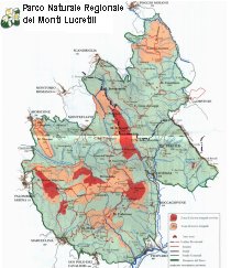
The Regional Natural Park of Lucretili Mountains , Instituted in 1989, extends on a territory of 18204 hectares and is marked by the majestic rises of the Monte Gennaro (1272 mt) and Pellecchia (1368 mt). It lies on the southern tip of the Monti Sabini hills, between the provinces of Rome and Rieti. The Lucretili Mountains are the largest mountainous group near Rome and the easiest to reach from the capital.

Monti Lucretili Park
Lucretilis Mons, a mountain of the Sabine territory, mentioned by Horace (Od. i.17,i) as visible from his Sabine farm, and probably identical with the Mons "Lucretius" mentioned in the Liber Pontificalis (ed. Duchesne, i.183), which speaks of "possessio in territorio Sabinensi quae cognominatur ad duas casas sub monte Lucretio" in the time of the emperor Constantine. The name "ad duas casas" is supposed to survive in the chapel of the Madonna della Casa near Roccagiovane, and the Mons Lucretilis is generally (and rightly) identified with Monte Gennaro, a limestone peak of 1271 m, which forms a prominent feature in the view NE of Rome. Excavations on the supposed site of Horace's farm were begun in September 1909.
The area is mainly limestone with numerous places of geomorphological and palaeontological interest. The stratigraphic series of Lucretili Mountains is mainly made of sedimentary formations of marine origins and environment, which began settling about 200 million years ago in the ancient Mesozoic ocean, Thetys.
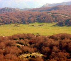
View from M. Gennaro
The scenery is pre-Apennine type. The orography of the area respects the general Apennine ranging with a north-south axis and represents a territory consisting of three main mountain folding separated more or less sharply by fault systems on which torrential engravings can be found.
The appearance of the range dominant the countryside around Rome, the Sabine and the tiburtin countryside clashes with the inner scenery characterized by a series of modest rises, alternated with karsts tablelands and valleys, perfect for grazing. This structure is interrupted by Mount Pellechia's ridge that gives the scenery a more harsh appearance in the southwest part of Licenza's area. The zone between Licenza and Percile is dominated by a milder sceneries.


